Cook County established the Property Index Number (PIN) system, officially known as the Permanent Real Estate Index Number System, in 1946. The modern 14-digit PIN encodes specific geographic information down to the unit:
05-17-417-020-0000
Area-Sub area-Block-Parcel-Unit
New Trier-Section 17-Block 417-Parcel 020-Standard Parcel
The county's official explainer and local lawfirms do a good job explaining the basic PIN facts and relevance for property taxes. Chicago Cityscape, a singular inspiration for this site, does a fantastic job (for a price) at aggregating property details for specific PINs. Property Sentinel is the only place you can type in a Cook County address and get all 311 complaints, property records & characteristics, and public listing details at that entire building—no matter the PIN number, could be none, could be 90—for free.
What Goes Into a Property Page
The Cook County Assessor publishes a number of separate datasets that we ingest on an ongoing, rolling basis. Key among these are the parcel universe (3.7 millions rows covering every parcel in the county), parcel sale history, assessed values, and property characteristics per class. For Chicago addresses specifically, we also have short term rental activity, 311 complaints, violations, and permits. This is only a partial accounting of our data infrastructure—see our Data Sources page for a full list.
The result is a property page that knows a building's latest assessed value (usually two years ahead of the city's own website), an indication if it's over-assessed (tool build in process), a complete set of characteristics, and full picture of listings/complaints/violations/permits.
The PIN Problem
Most addresses map cleanly to one PIN; Kevin McAllister's house at 671 Lincoln Ave is on a single parcel in Winnetka. Chicago's layers of large, old, and renovated buildings complicate this.
Cook County assigns PINs at the parcel level, and parcels follow legal lot lines, not building footprints. A courtyard building constructed on three contiguous lots has three PINs. A mixed-use building with a residential tower and a separate retail parcel has two. A landmark building occupying half a city block may have eight. If the PINs could talk, they'd tell you they're related—sequential PIN numbers at the same block or parcel with the same property tax mailing entity tend to be related—but there's no published record saying "these six PINs are actually the same building."
Take, for example, the historic Monadnock building. Designed by Burnham & Root back in 1891, 53 W Jackson Blvd. is still the tallest load-bearing brick building ever constructed.
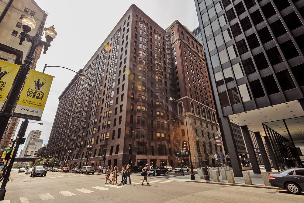
Except that's half the story—the other half of the Monadnock was designed by Holabird & Roche and wasn't finished until 1893. That's a second parcel with a separate PIN. It also has 32 other addresses:
300-350 S DEARBORN ST CHICAGO IL 60604
325-325 S FEDERAL ST CHICAGO IL 60604
50-56 W VAN BUREN ST CHICAGO IL 60600
51 W JACKSON BLVD CHICAGO IL 60604
The former is crucial for getting the full picture on property characteristics and taxes; the latter is important for everything else. To my knowledge, Property Sentinel is the only site to do both.
Sibling Pin Matching
Our matching heuristic identifies "sibling" PINs using a few signals in combination: sequential PIN proximity within the same block, shared tax mailing name, consistent property class, and a fourth proprietary method. When a certain combination of the four align, we flag the parcels as siblings and merge their records under a unified building view. Records from all sibling addresses feed into a single timeline, assessed values are summed, and building characteristics are itemized and deduplicated.
Our matching works well for the straightforward cases—courtyard buildings on the North Side, large mixed-use buildings, etc—but it breaks down on edge cases. That's why, when you type in an address for a building with multiple PINs, you're given the opportunity to view the full building or just the solo address.
Hansen 7
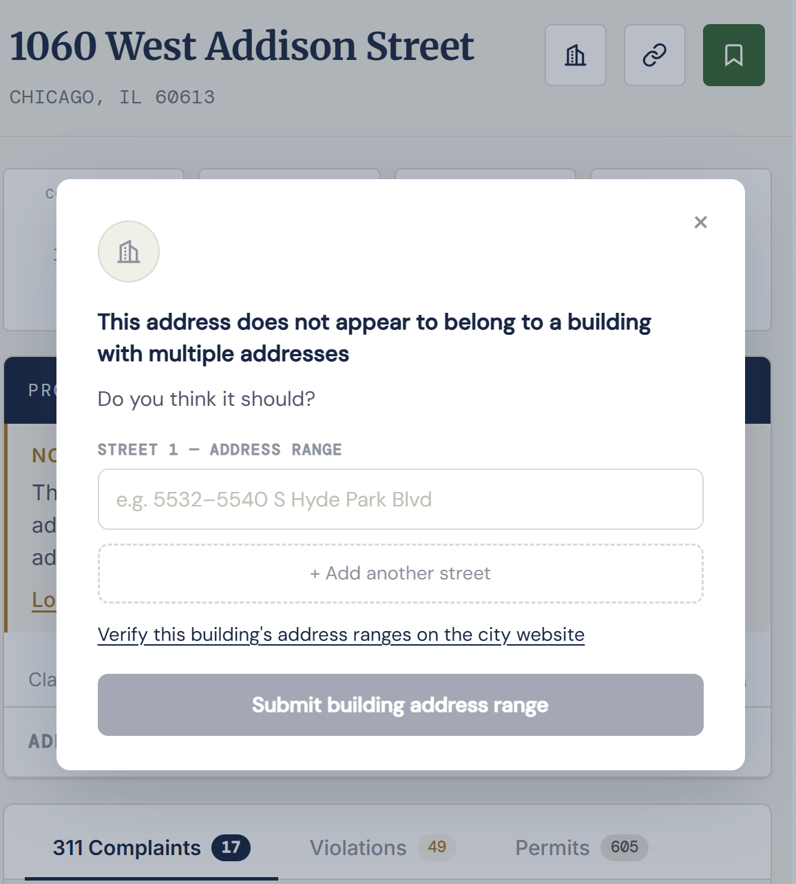
Our jigsaw puzzle is still missing an important piece. The city of Chicago maintains a legacy address range database called Hansen 7 that maps every building to its full street address range. It's the reason we know the definitive addresses for the Monadnock and it's also the reason why the neighbor's complaints about the illegal short-term rental in your condo association are lost to the wind. Right now, the only way to query Hansen 7 is through a back door, looking up an address on the city's building records site. Our parent company, City Logical LLC, has filed a FOIA request for the Hansen 7 dataset—if and when that request is granted, it will be freely uploaded to our Github and will complement our sibling PIN heuristic here.
Until we receive the definitive address ranges from the city, we rely on an elegant fallback. If you know your building occupies multiple address ranges—a courtyard building, a large multi-family, a condo association with a parking garage on an adjacent parcel—you can submit those ranges directly from the property page. And if you don't know your building's address range, you can verify it on the city's website. We review every submission against the parcel records and, when confirmed, merge them into a unified building view.
Search your address to get started.